 |
PUY de DOME |
|
PUY de DOME |
LIFESTYLE
There are more links at the top and bottom of each page.
These concern the administration of the site, but you should visit them just the same.
![]()


THE ABBEY OF BELLAIGUE
To see a larger image, click on a thumbnail.
You can contact me to order a full-size high-quality image.
E si vous voulez commander une image en plein dimensions et á haute qualité
Please if you would like to add anything to the text of each image or to correct an error.
Si vous avez des choses á ajouter, ou vous voudriez corriger quelque chose que j'ai écrit,

If Virlet were to have just one major claim to fame it would be the Abbaye de Bellaigue situated in the valley to the north of the village.
It is said that the abbey was founded by the Baron Odo of Montlucon round about 950 AD and placed under the care of the Abbey of Menat. But as you might expect, for reasons that I mention elsewhere there is no written document dating from this period that mentions the abbey. I've not seen any mention of any remains dating from that period and there is no indication that any archaeological excavations have taken place here to dig into the early history of the abbey.

There is a charter dating from 1136 showing that the Bishop of Clermont intervened in a dispute between the abbey and that of Menat and it was from this date that Bellaigue assumed its independence. The following year, the rapidly-expanding order of Cistercians took over the care of the abbey and this led to something of a golden age. Donations and bequests, of land as well as money, were frequent and substantial and it is said that many of the important donors purchased for themselves the right to be buried here.
This golden age couldn't last for ever. The Black Death and the turbulence of the Hundred Years War took a heavy toll on this area and the abbey suffered considerably. It lost its independence and became something of a political football, being kicked about between the Kings of France and the Pope, and also occasionally by some of the notable families of the area, all of whom fought with each other for the prestige of the possession of the abbey's rights.

Worse was yet to come. In January 1689 a major conflagration swept away the major part of the abbey buildings and the site was devastated. Reconstruction began, and there is in fact very little remaining from prior to this date, but matters proceeded at a very slow pace and the costs were said to be enormous. All kinds of disputes between all kinds of people about all kinds of things complicated matters even further. And while all of this was going on, the abbey was swept up in a downward spiral of doom and gloom.
The French Revolution saw the end of the Abbey and all religious bodies were disbanded. The State took over all of the possessions of these bodies, the Abbey of Bellaigue included, and in 1791 the abbey was put up for auction. It was bought by a local man who, once the fiery spirit of the revolution had calmed down, restored it to its rightful owners.
In June 1922 the abbey was classed as a Monument Historique and was added to the National Historical Register in December 1980.
Apart from its own religious significance the abbey had another significance in that in the Middle Ages it was one of the way-points for travellers walking along the Pilgrims' Way to Santiago De Compostela in Spain.
The Pilgrims would rest there before setting out on the next stage of the path, up into the village and along the ridge south-westwards before passing along the forest path through Les Coursieres and which passes about 200 metres from my house on the way to the next stop at La Cellette.

Anyone who knows anything at all about Historical Sites will know that Building Regulations are very strict, and anyone living within 500 metres of a Historic Building will have their building plans subjected to the tightest scrutiny to ensure that whatever they are planning to do conforms to the original specifications as much as possible and does not detract from the architectural or historical significance of the area.
So in the spirit of conformity and so on, here is an excellent example of early Medaieval corrugated iron roof on top of the Abbey church.
They must have been electing a new Pope when I took this photograph, I reckon. Unless it is the kitchen staff getting ready to make the evening meal. The diet, by the way, in an Abbey is very monotonous because only two monks are allowed to work in the kitchens - the Chip Monk and the Fish Friar.
The Abbaye de Bellaigue is situated at the foot of a steep slope to the north of the village. It is quite a climb from the abbey to here and is another indicator of the fact that people back in former times were much more hardy than they are today.
Perhaps it isn't quite the same as walking from the Mississippi to California but it's still something when you have to do it several times each day.
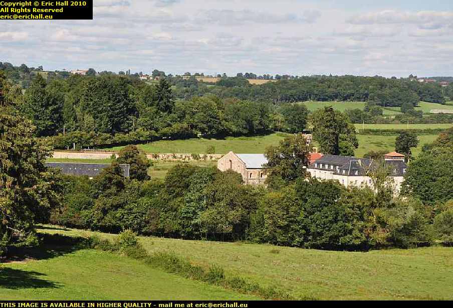
From the end of my lane, which forms part of the former Pilgrims' Way, there is an excellent view to the Abbey away in the distance towards the north. It is the large light-coloured building in the centre of this photograph.
The village of Virlet is situated at a height of 528 metres so one assumes that the abbey is about 50 or 100 metres lower that that in the valley. On the other hand, I'm a good 100 metres higher up than the village here, on the top of yet another ridge.

The relative heights of the village and abbey can clearly be seen in this photograph. The Abbey is away on the right-hand edge of the image, yet peering through the electricity cables to the left of the image you can see the church spire poking out through the trees
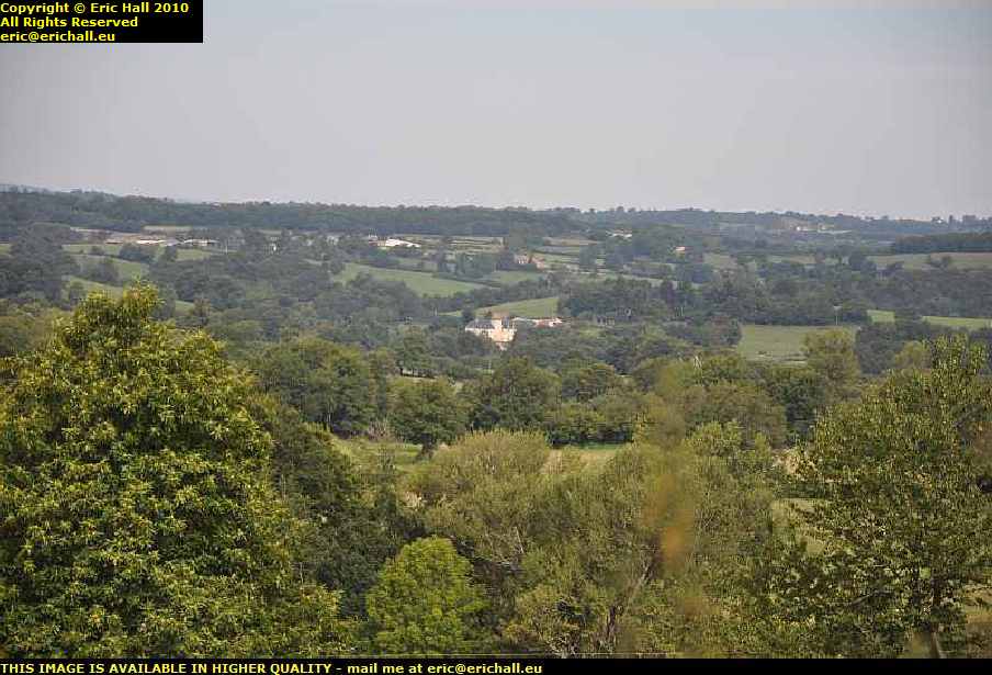
The end of my lane is quite a vantage point to observe the comings and goings of the village and the abbey, especially in winter when the foliage has died off.
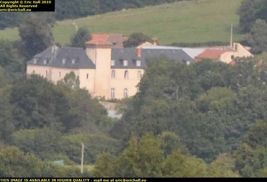
Judicious use of a long zoom lens and the cropping facility of a decent graphics program has produced this excellent close-up view of the abbey. It's hard to believe that this image is 6kms away from where I took the photograph.
The patch of road that you see in the foreground close to the telegraph pole is the apex of one of the hairpin bends that winds up from the abbey to the village.

This is a photo taken from the same spot in February when there is no foliage on the trees to obscure the view. The Abbey is more-or-less in the centre of the shot. The dark line just below the horizon - a line of trees - is the limit of the commune and also incidentally the limit of the Département of the Puy-de-Dôme. Over there in the distance is the commune of Ronnet in the Département of the Allier.
The hill away in the centre-distance is, I reckon, the Croix de Fer near Arpheuilles-St.Priest, about 12 km away. From that point there is a steady descent all the way to Montlucon which is about 30kms from here.
home page | back to top
about this site | audience participation | copyright notice | technical issues | accessibility statement | read this | contact me
©