 |
PUY de DOME |
|
PUY de DOME |
LIFESTYLE
There are more links at the top and bottom of each page.
These concern the administration of the site, but you should visit them just the same.
![]()


VIRLET HISTORY
To see a larger image, click on a thumbnail.
You can contact me to order a full-size high-quality image.
E si vous voulez commander une image en plein dimensions et á haute qualité
Please if you would like to add anything to the text of each image or to correct an error.
Si vous avez des choses á ajouter, ou vous voudriez corriger quelque chose que j'ai écrit,
No-one has any real idea of the ancient history of the village. Written history of the village from those days is negligible to the point of being absent, but then that's hardly a surprise. A brief history of France will reveal that there has been nothing but a continual series of turbulence in the country up until probably 1968 - dynastic disputes, the Hundred Years War, religious conflicts, revolutions, occupying powers, student demonstrations and all that kind of thing - so besides the usual looting, raping and pillaging, the French national sport of sacking Government buildings on a regular basis and the theft (if not the total destruction) of official documents has left gaping holes in the official memory.
It's no surprise therefore that much of the earliest reminiscences of the village has come from either oral tradition or else from external religious sources. The Vatican is well-known as one of the most assiduous of record-collectors, even though Edward Gibbon in his Decline and Fall of the Roman Empire comments that
"every record that comes from the Vatican is justly suspected"
surely an extreme position to adopt for a writer of his stature.

Back in the dim and distant past the village didn't have its own church - apparently depending upon the Abbaye de Bellaigue for its religious services and the Abbey stood proudly upon its right. This doesn't say what the villagers did for worship before the Abbey was built - always assuming that there was a village here prior to then, and I'm going to mention this in a minute.
The villagers were somewhat unimpressed by this and made a plea to the local bishop for their own church, and in a Papal Bull (which is something that the Pope sends out to deal with other peoples' Sacred Cows) of 1107 established a church under the protection of the Abbey of Menat.
There is also another document dealing with a dispute between the Abbeys of Menat and Bellaigue, in which the church of Vilarei - without doubt the village of Virlet - is mentioned.

A quick glance at this photo is sufficient to demonstrate that this is such a crucial and important site, and so I can't believe that it was unoccupied at the time the church was built. I would have expected that someone would have already chosen this point for a building, and a building of some significance too.
It's hardly on a par with the typical site of a Neolithic or Iron-Age Hill Fort but someone like Vercingetorix, looking for a likely place to put a small regional centre that would have had a chance of holding out against the Romans until a relief column could arrive, would not have overlooked a situation like this. It's infinitely better than hiding in a hole in the ground, which was the resort of many villagers around here during the more turbulent moments of the Dark Ages, for heaven's sake.
It would be interesting to see whether any archaeological excavations have taken place up here in the past. There must be all sorts of exciting relics here awaiting discovery.
But all of this notwithstanding, an inspection of the church here in the 19th Century dates some of the oldest work to maybe the 13th or 14th Century, and it has been considered that there might have been a wooden structure on here before.
But I remain unconvinced by this. Although there is wood a-plenty around here, there is also a superabundance of stone as any gardener around here will tell you and I can't see why during the major epoch of church-building financed in the main by loot returning from the Crusades, they would go for a temporary wooden religious building when everything is at hand for a more-permanent stone one. What we see of the church today is in fact built of local granite.
The earliest date that one can see on the building itself is a lintel with the date of 1688 carved in it.
One thing that is abundantly clear is that the church has been progresively enlarged, and on several different occasions too. One thinks of many English churches, the one at Down Ampney being a fine example, where the church was progressively enlarged over a lengthy period to cater for an ever-expanding village population, displaying a variety of styles dating from Early Norman to Victorian Frightful. Looking at this church one can see a similar process of evolution, and it may well be that any original work has been swept away by a subsequent modernisation.
There is a document of 1813 that describes the bell tower as "new" and that the "new part" of the church, probably the widened nave, was then without windows so it is clear that some time round about the turn of the 19th Century a good deal of work was undertaken.
The interior of the church, which is dedicated to St Fiacre by the way, is quite modest and is in a very good condition, although it hasn't always been like this. An inspection of the church in 1842 reported that ice and rain had caused a good deal of damage to the church and, despite the renovations of just half-a-century earlier, it had "cracked from end to end" and was in danger of falling down.
In the 1860s the parish priest, Father Faure, motivated the parishioners into a programme of repairs and even more enlargements were made at this time.
It makes me wonder what kind of turbulence or unrest happened here during the early years of the 19th Century that played a role in all of this. At the beginning, the villagers felt confident enough to embark upon an extensive course of modernisations and improvements but then effectively abandoned the project to the elements. Why?

But that isn't the full story of the church. In the autumn of 1999 I spent three months living down here on my farm and on 26th December of that year, a fit of divine retribution summoned up a hurricane which caused the spire to collapse. This fell into the church causing considerable damage, and led to another programme of restoration, which has been completed quite sympathetically.
On the wall is a series of religious paintings depicting the Chemin de la Croix - the route that Jesus took on his way to the crucifixion at Gethsemane. It's nice to see them here on display in a reasonable condition - a far cry from what is happening 15 miles away and which ought to be a national scandal.

In this photo we are looking north-east from the village right along the scarp slope that forms the edge of the Monts de la Combraille. The view is quite impressive.
Virlet has a most interesting site and situation, about which I have already spoken at great length, so much so that it bewilders me how come it's attached to Montaigut-en-Combraille for administrative purposes. It's situated on the brow of a steep scarp slope that is actually a promontory marking one of the last outcrops of the Monts de la Combraille, rather like a finger pointing into the valley below surrounded on two sides by a very steep climb, a third side where the climb isn't quite so steep but significant nevertheless, and the fourth side that is the line of a ridge.
So imagine your typical half-decent and self-respecting feudal baron erecting his castle up here. It's certainly the ideal place to do so. He could survey the plains all around here from this height and his castle wouldn't need much in the way of defences. It would protect itself from attack from the north-east - the direction to which you are looking - and which, incidentally, is the direction in which Montaigut-en-Combraille is situated - quite easily by virtue of the steep climb up from the plain. The steep climb would also protect the castle from the north-western side and the not-so-steep climb from the west could be defended by a stout wall
The line of retreat along the ridge-top, along which relief would also be sent if the fortifications were ever to be beseiged, leads south-west in the direction of Pionsat.

Approaching the village from the direction of Montaigut-en-Combraille, you can observe something of the difficulties of access from the north-east. In modern times the road has beed diverted from its former path and makes a curving approach along the edge of the ridge further east.
In medaieval times the road came straight up the hill. You can see the traces of it in the valley down below; it's the hedgerow line running diagonally across the photo from lower right to mid-left

A photograph taken from a slightly different angle just a little further round to the north gives perhaps a better perspective. The steepness of the slope down to the old road is much more in evidence and by consequence the steepness up the slope at the other side can be interpreted by considering how the old road rises even though it is running diagonally across the slope from lower right to upper left.
The buildings in this photo are, from left to right, the church, the former presbytery and the mairie.

The old road emerges into the village at the foot of the Maison des Associations. The steepness of this road should give you a good appreciation of exactly what I mean about the approach to the village from the north-east direction in times gone by.
So taking this into consideration, how come Virlet, or Virelet as it is known on the old Cassini maps, is attached to Montaigut-en-Combraille? It's not logical. I would have expected the village to have been something of an outpost of Pionsat in Medaieval times, given the ease of access along the old ridgeway.

This is the view looking towards the northern aspect of the village, and the point from where I took the photos of the old road is the gravel patch on the left-hand edge of this photo - you can just about make out the picket fence. The Maison des Associations is the cream building that is the farthest left.
Although the slope up to the church doesn't look much from here, I'm standing about a mile away and looking right across the river valley, and so the perspective is somewhat deceiving.

A photo taken from the reverse angle gives an even better appreciation of the terrain and the lie of the land, and you have a much better idea of the steepness of a slope.
An army of marauding English knights in full armour during the Hundred Years War - for all of this area was quite a battlefield during those days of chaos in France - would find great difficulty charging up this slope and would be easy prey for the local Auvergnat archers and pikemen waiting on the heights up here.

You've seen how difficult is the access to the village from the north-eastern side. It would have been almost impossible from the northern side, with having to surmount this obstacle.
From the small river that runs past the outcrop on which the village is situated, the modern road zigzags up the hill in a series of sharp bends in an effort to negotiate this steep bank. Medaieval knights in armour didn't have this kind of luxury and would either have to do their best up the bank or else follow whatever cart track that might have been between the village and the Abbey at the foot of the hill.
These narrow cart tracks with blind bends between earthen banks or hedges could be positive death traps. Anyone with any kind of military intuition could have set up all kinds of ambushes in places like that.

The approach from the west, the direction of St Fargeol and Marcillat-en-Combraille, isn't much easier either. The hill might not look so steep but it is difficult enough in modern times on a bicycle, despite the metalled road. On a dirt track in a suit of armour on a horse it would still present a major obstacle.
A stout rampart just below the crest of the hill just here, fronted by some kind of ditch, and a spirited defence could hold up an attacking army here for days, certainly long enough for relief to be sent to the village.
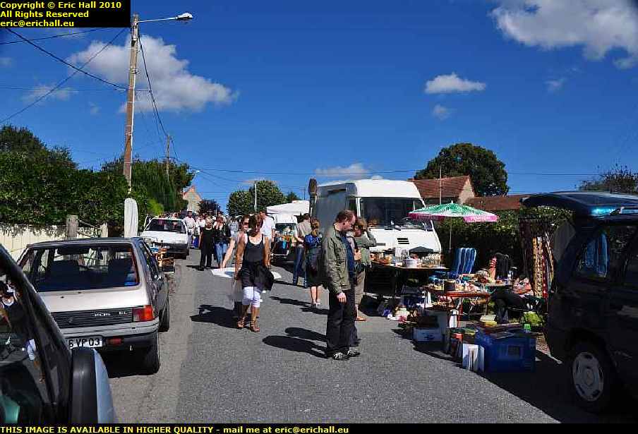
A shot from the reverse angle in happier times shows a different perspective on village life. The Combrailles has to be the centre of the brocante world and the locals will vider their greniers at the drop of a hat.
The last Sunday in August is the Virlet brocante and it always attracts quite a crowd. Unfotunately brocantes aren't what they once were, and these days some of the most astonishing prices are being asked for some of the most banal items. People seem to prefer making a killing on one article rather than a pittance on each of a thousand, something I don't understand. After all, you have to take your unsold articles home with you in the evening, which is hardly the point if you have come here to vider your grenier.
Mind you, a couple of people reckoned that they found themselves a bargain.

A photograph taken from a little further back along the ridge to the south-west of the village and looking to the north-east doesn't show you the slope, but you can imagine how it must be from noting the valley in the middle distance.
The small town in the far distance, around where the water tower is situated, is Marcillat-en-Combraille, in the département of the Allier.
And this is another irony too - while Virlet is attached to Montaigut-en-Combraille for administrative purposes, for postal purposes it is attached to Pionsat and for social purposes it is attached to Marcillat-en-Combraille, which not merely being content to be in a different canton, is in a totally different département. It's almost as if no-one wanted Virlet and so they shared it out, making each of the neighbouring cantons take its share of the suffering.

During a guided walk around the village in July 2010 we were told that this is the oldest house in the village. At one time it was the local tobacconist's and still bears the red emblem fastened to one of the exterior walls. It's difficult to imagine that maybe 100 years ago these derelict and decaying villages were thriving hubs of commercial activity with all kinds of shops, commerces and estaminets. But World War I in which the peasants from these areas were used as cannon fodder and massacred in their countless thousands in the trenches, followed by the flight to the towns in the 1950s and 60s, did for them all.
One old guy recounted the most fanciful stories about this house - that it was used as a kind of foster home for one of the future Bourbon Kings (the Bourbonnais from whence they came not being too far away from here) and all that kind of thing - but it was very difficult for me to say whether or not he was merely making pleasantries.

One claim to fame that Virlet proudly announces is that it is home to an oeuvre by Valentin Vigneron. He was an architect from Clermont Ferrand in the early years of the 20th Century and he married a girl from Pionsat. Probably for this reason he was engaged to design several buildings in this area.
Peering through the trees is the Moulin de Bellaigue, Bellaique being a corruption of the Latin Belle Aqua or "Sweet Water". This is one of Vigneron's most important works in the area and is situated about 800 metres from the abbey. I'll go back and take a photo of this in the winter when there are no leaves on the trees so that you can have a better view of his work.
Another one of his works, loudly trumpeted, is a barn in the vicinity of Pionsat. So a barn and an industrial mill building as his most important works in this area - I'm not quite sure what we are supposed to deduce from that. Perhaps hiding it behind a bunch of trees was the original aesthetic idea.
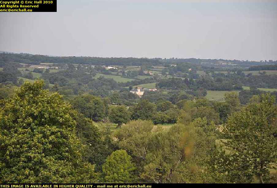
If Virlet were to have just one claim to fame it would be the Abbaye de Bellaigue situated about a mile or so from the village.
From the end of my lane, which forms part of the former Pilgrims' Way, there is an excellent view to the Abbey away in the distance towards the north. It is the large light-coloured building in the centre of this photograph.
The village of Virlet is situated at a height of 528 metres so one assumes that the abbey is about 50 or 100 metres lower that that in the valley. On the other hand, I'm a good 100 metres higher up than the village here, on the top of yet another ridge.

The relative heights of the village and abbey can clearly be seen in this photograph. The Abbey is away on the right-hand edge of the image, yet peering through the electricity cables to the left of the image you can see the church spire poking out through the trees
The end of my lane is quite a vantage point to observe the comings and goings of the village and the abbey, especially in winter when the foliage has died off.

Judicious use of the long zoom lens and the cropping facility of a decent graphics program has produced a close-up of the village. Not quite as excellent as the previous one due to all of the foliage, but just wait until January when I shall be back here to take a photo without all of the foliage in the way. I shall also bring a pair of insulated bolt cutters to clear other encombrances from the field of vision.
The building just behind the church is the old presbytery, now the municipal library, and the other building to the right of the image is the mairie. Now, does anyone know where I can buy a war-surplus 105mm German field gun? I could have loads of fun with that from up here. You can see now why the principle of fortified castles became totally redundant with the advent of artillery.

This is a photo taken from the same spot in February when there is no foliage on the trees to obscure the view. The abbey is in the centre of the image.
The dark line just below the horizon - a line of trees - is the limit of the commune and also incidentally the limit of the Département of the Puy-de-Dôme. Over there in the distance is the commune of Ronnet in the Département of the Allier.
The hill away in the centre-distance is, I reckon, the Croix de Fer near Arpheuilles-St.Priest, about 12 km away. From that point there is a steady descent all the way to Montlucon which is about 30kms from here.

Out of interest and pure curiosity "and nothing better to do" - ed I took myself along to the Croix de Fer to search for a suitable vantage point to see what I could see, and whether it might be anything of any significance.
I found a suitable gap in the hedge along the road and taking some rough kind of counter-bearing I took a photograph of what might be in a suitable direction.

Not a mile away from where I live is a huge house that has recently been built on a prominent eminence and the house has been rendered in a brilliant white colour. I've noticed in the past that it is visible from a long way, especially during winter when there is little foliage.
And one of the advantages of having spent a lot of money on a really expensive long lens and taking photographs at a very high resolution is that you can crop tiny fragments out of images and blow them up to a really impressive size, so that a distance of 12kms becomes a mere bagatelle.

The focal point of the brocante, which I mentioned earlier, is the village square, such as it is. It isn't much of a village square compared to some places, I agree, but with a population of just 271 people, you only have a limited budget to play with and there are all kinds of things that have a much higher priority than doing a few cosmetic improvements.
Just like every French village that I have ever seen, Virlet has a war memorial to its deceased soldiers. And while the number of deceased in World War II is not significant (Virlet came under what was known as "Vichy France" and it was the American invasion of French possessions in North Africa during Operation Torch that brought the Germans here in 1943, something that rankles with the locals even today and something that many Brits and Americans don't seem to understand), the number of dead from World War I is astonishing.

I counted 37 names on the memorial here, which for a village of 950 inhabitants in 1911, is a frightening proportion. And all the villages around here suffered in similar proportions. Generally-speaking, the peasants from rural areas such as this and who were conscripted into the Army in 1914 were considered to be unsuitable for technical work and so made up the greatest proportion of cannon fodder as infantry in the trenches.
With the huge mincing machine that was Verdun and many similar places besides where the casualties were enormous it was these poor blighters who were in the first waves of attack, charging the barbed wire and machine guns of the entrenched German forces and they were mown down by the tens of thousands.
The census of 2005 revealed that the village has a population of 271, which shows just how steeply has been the rural decline over the last century as the flight to the town gathered pace. But that represents an increase from the 1999 figure of 245 inhabitants. And I tell you what - I bet that most of the increase is accounted for by foreigners looking for some of the greenery and wide open space that there is here in rural France where the quality of life is just so much better than in the cramped and stressed-out urban environments of the UK and the Netherlands.
It's not as if there is any shortage of wide open space either. These 271 people live in just over 17 square kilometers, the surface area of the commune - that's about 16 people per square kilometer. And there are plenty of places to live, too. Ruined houses abound here, long-since abandoned by the heirs of those who fled to the towns. They make ideal DiY projects for ambitious foreigners and many an impoverished farmer, not to mention the local baker, grocer, butcher, DiY shop proprietor (the list in endless) has cause to be grateful to the substantial influx of foreign cash that has kept this area afloat.
To put it into perspective, there are approximately 2,000 "foreign" households in the Combrailles, almost all of them North-European in origin. Now if each household has invested, say €80,000 in their house, purchasing and renovating it, and in what they have spent in local shops, services and taxes, that represents €160,000,000 that has come into this area, and not from the national coffers either but from abroad - totally new money to the area and totally new to the French government too. How many people have cause to be grateful for this? And what would happen if all of the nouveaux arrivants became fed up and left, taking their money with them?
home page | back to top
about this site | audience participation | copyright notice | technical issues | accessibility statement | read this | contact me
©